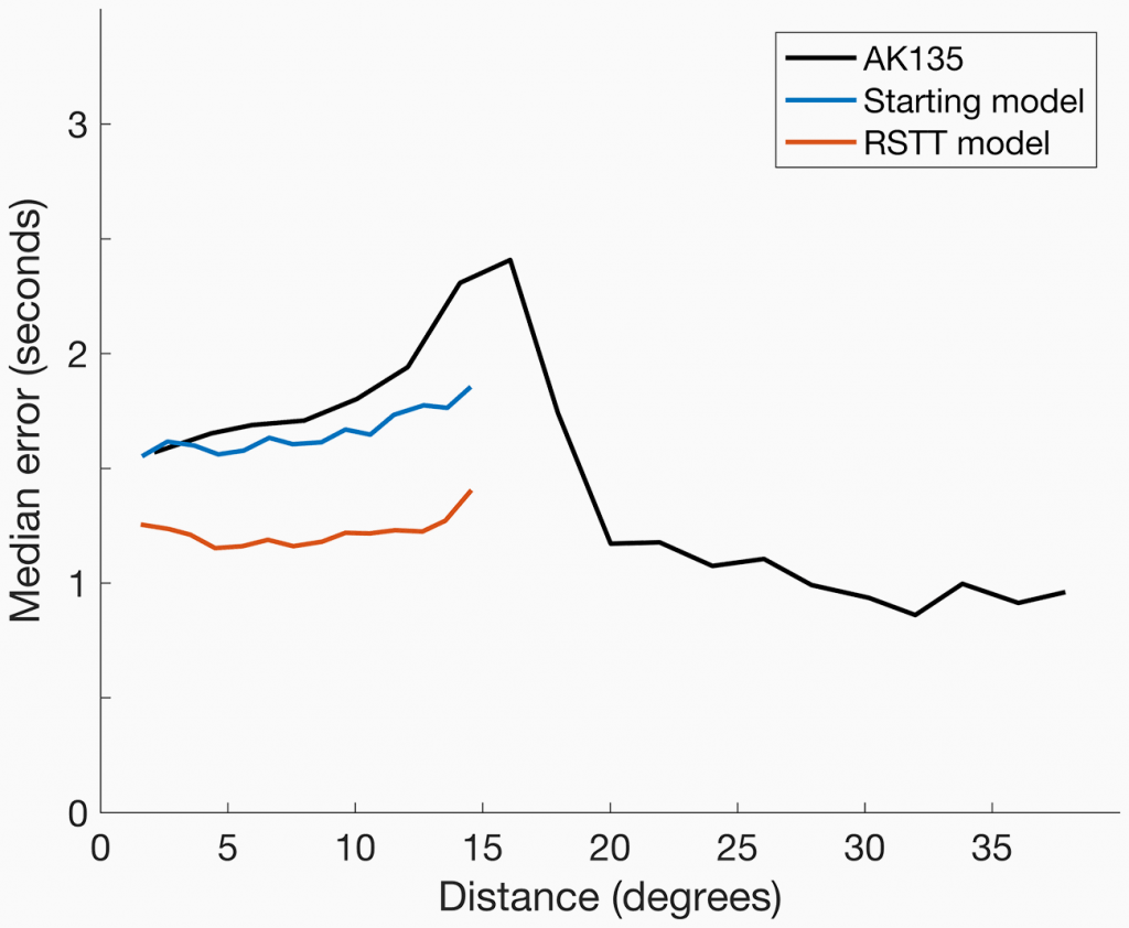
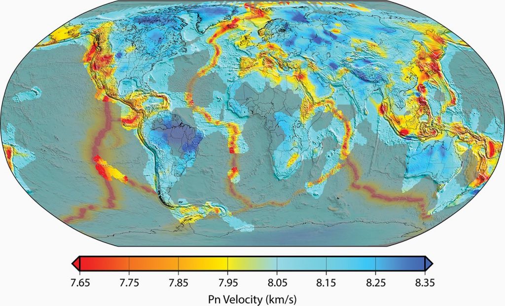
Traditionally, seismic monitoring relied on observations of teleseismic phases which travel predominately through the lower mantle. In the 1990s, in order to lower monitoring thresholds, the use of regional phases began to be explored. However, regional seismic phases spend most of their time in the crust and upper mantle which are considerably more laterally heterogeneous than the lower mantle. This heterogeneity increases the complexity of regional phase raypaths and results in reduced travel time prediction accuracy when using global 1D models that were adequate for teleseismic phase prediction. Accurately locating events using regional seismic phases, therefore, requires use of a model that varies geographically, i.e., a 3D model.

However, producing fully 3D tomographic models and computing ray-traced travel times through them rapidly becomes computationally expensive as the resolution increases. A further challenge is that some events include both regional and teleseismic data, which means that 3D models used for regional phases and the well-tested 1D models used for teleseismic phases must fit together seamlessly. To address this problem, in the late 2000s the U.S. National Laboratories developed the Regional Seismic Travel Time (RSTT) method, model, and software.
RSTT improves travel time prediction accuracy by developing a 3-dimensional model that accounts for structural heterogeneity of Earth’s crust and upper mantle (Myers et al., 2010; Begnaud et al., 2020). The RSTT tomographic method, developed by Phillips et al. (2007), builds upon a mantle-velocity gradient method introduced by Zhao and Xie (1993). Importantly, it implements an approximation to ray tracing, which enables the computation of a travel time in approximately 100 microseconds on a modern laptop computer (Myers et al, 2010). This computational speed makes RSTT practical both for use on operational systems and by researchers who do not have access to advanced computational resources.
The utility of RSTT for nuclear-explosion monitoring prompted the U.S. government to offer RSTT to the CTBTO PrepCom for use at the International Data Centre (IDC) in 2012. Since delivery to the IDC, RSTT has been evaluated by IDC staff and technical representatives of CTBT member states. In April 2020, a U.S. National Nuclear Security Administration (NNSA) team from Los Alamos, Lawrence Livermore, and Sandia National Laboratories delivered a significant update of RSTT monitoring technology to the IDC.

The April 2020 delivery is the product of several years of development, and it incorporates almost a decade of new data into the RSTT geophysical model (Myers et al., 2007, 2009; Begnaud et al., 2020). The update also includes path-specific calculations of travel time prediction uncertainty (Begnaud et al., 2021). As a result, accurate regional travel time predictions for the four regional phases commonly used for monitoring (Pn, Pg, Sn, and Lg) have been extended to all continents and oceanic areas where seismic events occur.
The U.S. National Laboratories also worked with IDC staff to precompute travel-time corrections for each regional phase on a predefined grid of points in the region surrounding each International Monitoring System (IMS) seismic station (a.k.a. Source-Specific Station Corrections, SSSCs, Firbas et al., 1998; Ritzwoller et al., 2002; Morozov et al., 2005). Use of SSSCs is the easiest way to implement RSTT at the IDC in the short term, and full integration of the RSTT code will further improve performance. Implementation of RSTT-based SSSCs at the IDC brings accurate regional seismic travel time prediction to the entire IMS; SSSCs were only available for approximately one third of the IMS prior to the RSTT update.
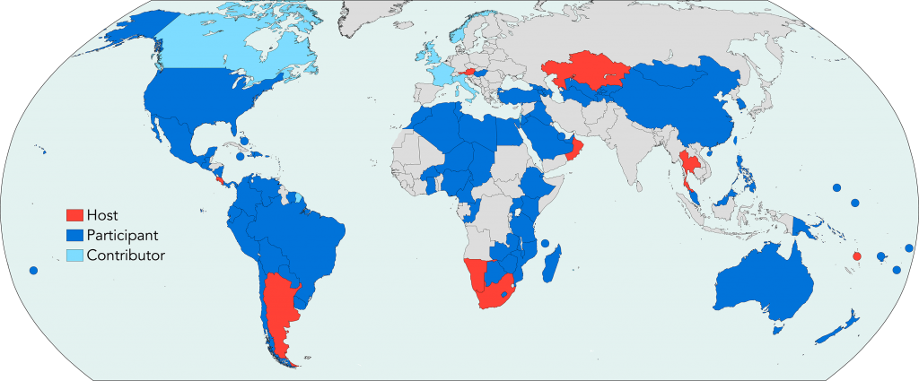
In addition to use at the IDC, RSTT has become a mainstay in CTBTO PrepCom capacity building efforts. The CTBTO PrepCom has incorporated RSTT into eight international training activities since 2012. In addition, RSTT has been the focal point of ten special sessions at scientific conferences. As a result, personnel from National Data Centers (NDCs) and academic researchers from Africa, Asia, Australia, Europe, North America, South America, the Middle East, and Oceania have been trained in the use of RSTT. Training sessions and professional conferences foster international collaborations that have contributed geophysical information and data that improve the RSTT model. These improvements extend the geographic coverage of RSTT tomography and supply important ground-truth data that make travel time calculations more accurate in areas where scientific collaboration has taken place. These data contributions and the RSTT model are openly available to all NDCs and the broader research community.
