Sandia Labs, Ohio State look to the skies to protect aircraft against GPS outages

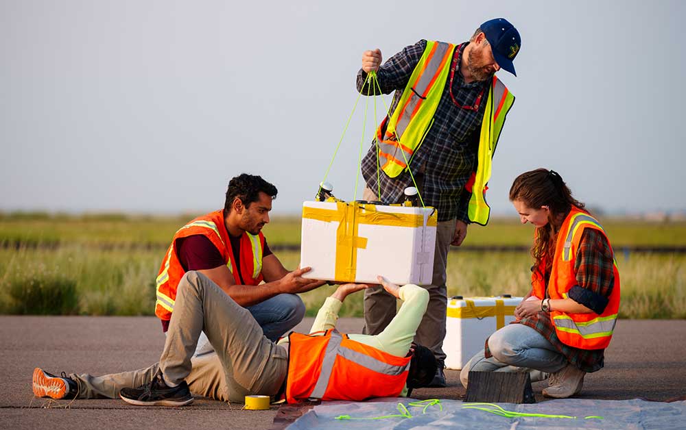
Dangling from a weather balloon 80,000 feet above New Mexico, a pair of antennas sticks out from a Styrofoam cooler. From that height, the blackness of space presses against Earth’s blue skies. But the antennas are not captivated by the breathtaking view. Instead, they listen for signals that could make air travel safer.
Researchers from Sandia and Ohio State University are taking experimental navigation technology to the skies, pioneering a backup system to keep an airplane on course when it cannot rely on global positioning system satellites.
More than 15 miles below the floating cooler, cell phone towers emit a steady hum of radio frequency waves. Hundreds of miles above, non-GPS communications satellites do the same.
The idea is to use these alternative signals to calculate a vehicle’s position and velocity.
“We’re not trying to replace GPS,” Sandia lead researcher Jennifer Sanderson said. “We’re just trying to assist it in situations where it’s degraded or compromised,” which can lead to dangerous situations for pilots and passengers.
The team presented its preliminary data at the Institute of Navigation GNSS+ conference, held from Sept. 16-20 in Baltimore. The research is supported by Sandia’s Laboratory Directed Research and Development program.
The case for a GPS backup
There is no question GPS is still the gold standard for navigation. It’s fast, precise and reliable. Which might raise the question: Why are researchers developing new navigation methods?
“I worry about relying too heavily on it without a backup,” said Jennifer, an expert in navigation algorithms.
GPS, she said, has become part of the fabric of our modern, technological world. As a society, we are constantly plugged into it, whether we are landing a plane, driving through town, mapping crop yields or timing transactions in stock markets. This reliance has researchers like Jennifer concerned about the consequences if the connection is disrupted.
“The impacts of losing GPS could be felt throughout society,” she said.
Disruptions to GPS are not uncommon. Pilots flying near conflict areas are increasingly likely to lose GPS or discover it is unreliable. The longer they fly without GPS, the higher the risk of accidents.
“Commercial GPS receivers are susceptible to a couple different threats, one being jamming,” Jennifer said. Jammers, devices that overwhelm receivers with meaningless signals on GPS frequencies, are illegal but commercially available.
Another problem, she said, is spoofing, which involves using a fake signal to mislead receivers into believing they are in a different location. The technique is no secret, as gaming communities use it to cheat in location-based games like Pokémon Go.
“There are actual apps you can download that allow you to spoof your location, and entire subreddits dedicated to showing you how to use it for various games,” Jennifer said.
While spoofing a game may be relatively harmless, Jennifer emphasized it can have real-world consequences when directed at a vehicle. Pilots might not be able to tell if a signal is spoofed or genuine, leading them in the wrong direction.
Project studies signals-of-opportunity at high altitude
Jennifer’s idea of navigating using non-GPS signals that happen to be nearby is not entirely new. Scientists refer to it as “signals of opportunity” but have primarily studied it on and near the ground. It has been proposed as a way for autonomous vehicles to navigate through urban canyons, where GPS signals are blocked by towering buildings.
However, it is not a simple task. Instead of extracting time and location information from a GPS signal, receivers of signals-of-opportunity sometimes measure the physical characteristics of radio frequency waves instead.
For example, they can use what’s called the Doppler effect. Radio waves from a satellite moving toward a receiver become compressed as they travel, while radio waves from a satellite moving away become stretched out. With some advanced mathematics and enough signals, scientists can determine the source of the signals and calculate the receiver’s position.
Jennifer and her team are studying signals-of-opportunity navigation at high altitudes. If they can collect signal data from the stratosphere, they may be able to develop a way to guide vehicles, such as aircraft, using a network of atmospheric radio frequency waves.
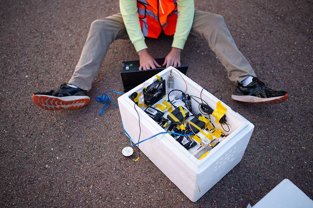
“So, we strap our payloads to these weather balloons and launch them into the air,” she said.
The payloads, which consist of electronic packages attached to a pair of antennas and bundled into an insulated foam cooler, hold the key to understanding signals high above the clouds. Satellite signals are expected to be strong, but there may be dead zones due to the cone-shaped transmission pattern that narrows closer to the source. Satellite coverage over rural areas, like much of New Mexico, may be too sporadic to be useful. The strength of cell tower signals can be calculated theoretically, but it needs to be characterized to be useful in a real-world situation.
“So far, the highest altitude we’ve reached is about 80,000 feet. In comparison, other studies we’ve seen have focused on 5,000 to 7,000 feet.”
Processing data is the next step of team’s scientific journey
As researchers continue to process their first batch of data, they look forward to new milestones and new challenges.
“The not-sexy but very important side of navigation is understanding all your error sources,” Jennifer said. “My goal is to have a robust dataset to develop algorithms for real-time systems, enabling hardware tests using actual live-sky data.”
Eventually, a functional navigation system will need to match signals to their transmitters in real-time and then calculate position and velocity relative to those sources. However, in this early stage of the research, her team is manually matching received signals to nearby satellites using reference data.
“It can be quite tedious. So, one big aspect we need to address is automating this process,” she said.
Despite the challenges, she remains optimistic.
“While we are still processing the flight data, we believe our preliminary findings indicate that we detected cell tower signal beacons at our peak altitude of about 82,000 feet. If these signals are clean enough for navigation, it will significantly change what we thought was possible for alternative navigation,” Jennifer said.